Monday, May 14, 2012

Highway to Heaven

(SDA: Day 4) 


      Morning greeted us with cool, crisp air, and a beautiful sunrise that brought the brilliant colors of the badlands to life. With our camp packed up and in the car, we drove back through the park. We took a different route out of the park. This route brought us face to face with buffalo. It was Michelle and Saumya's first time seeing one. We also saw another bighorn sheep, lots of prairie dogs, a burrowing owl, and a MASSIVE golden eagle.

A Bighorn sheep.
Big Buffalo!!!
The Golden Eagle flying away from us.
You know you are in South Dakota when Prairie Dogs outnumber people 10 to 1.
Just barely managed to snap this picture of the Burrowing Owl. It was pretty skittish. 

Leaving the badlands behind us, we flew down I-90 toward the black hills of South Dakota. We passed Ellsworth AFB and sadly didn't see any B-1s. We hopped off the interstate and cruised for a while before we came to Mount Rushmore. Both Nathan and I had seen it, but it was the first time visiting the monument for Michelle and Saumya. There are some trails that lead close to the base of the carved faces and we hiked those. We tried to get a picture of Michelle kissing Mr. Washington, but I am not sure that it turned out so well.
Saumya and Michelle enjoying Mt. Rushmore.
Washington, Jefferson, Roosevelt, and Lincoln all look a little stiff in this picture.


Kissing George.
Nathan and I proving that we really were there.

Did you know that originally, the presidents were going to have their bodies carved into the rock as well? Unfortunately, it didn't work out because the rock wasn't suitable, so that is why it is just their faces. Although, if you look closely, George has a bit of his coat carved. We all agree though that Abe should have his hat though.

Saumya standing by a model of what Mt. Rushmore was supposed to look like.
Having soaked up Mount Rushmore, we stopped at a place called Teddy's Deli in Keystone. They had some pretty good sandwiches. Filled with food and energy, we piled into the car (which we had repacked that morning, so now there was a bit more room...key words...a bit!) and started for Custer State Park. I have to say, the road that lead from Rushmore to Custer Stat Park is A-W-E-S-O-M-E!!!!! It twists, it turns, it has CORKSCREWS, and then there are narrow tunnels only one car can fit through. And if you look north through them, the tunnels perfectly frame Mt. Rushmore!!!!! I would totally do that section of the trip again...just for the road!!!!

One of the tunnels we passed through. As you can see, Mt. Rushmore is perfectly framed.
We entered the park and drove the wildlife loop were we saw more buffalo, more prairie dogs, more antelope, and our first wild burros!

The Burro posed for us. Wasn't that nice?
At the south end of the wildlife loop we made a jaunt south to Wind Cave National Park, to do a tour of the caves we would have had to wait a couple of hours, so we decided to just skip it (but at least we can say we have been to that national park :) ). We then joined back up with the wildlife loop and continued north to needles highway where we heard that white mountain goats had been spotted earlier. Before we got to that section we hiked Cathedral Trail which leads up rocky terrain to a section of rock pillars. That was an easy and fun hike to do.

Being adventurous, I scaled this massive mountain!!!! 
OK, as you can see, it wasn't that big!
Several rock pillars on Cathedral trail. 
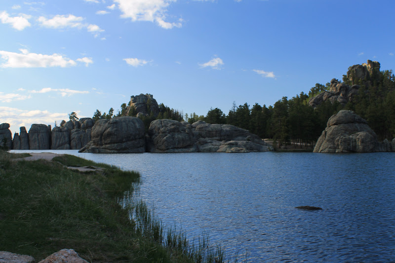
 Once down we did the only thing you can do. Eat chocolate! :) OK, after that, we kept going and passed through some more cool tunnels. Sadly, we didn't see and mountain goats. Michelle wanted to go to Sylvan lake, so we drove there and stopped. The combination of the deep blue water and massive grey rocks made it beautiful. Other people must have thought so as well, because by the lake, chairs were set up for a wedding that was going to take place later that evening.

Sylvan lake.

I think they are trying to tell us "the lake is THAT way."
Having seen everything that we wanted to see, we left Custer State Park, and drove out of the Black Hills, and got back on I-90 and started to head back east. We made it to Murdo, were we got a hotel for the night. The receptionist was really nice. She gave us a discount and begged us to take all of the cookies off of a platter in the lobby--we obliged.

End day 4.              

May The Trail Be With You

(SDA: Day 3)

      Well, the morning of the big day. What big day, you may ask. No, not a wedding. No, not a spaceship ride, but that one is close. It's the day I get to go to Badlands National Park! My companions for the trip were still a few hours away from were I was staying with my aunt and uncle, so my uncle and I went and breakfast and coffee. There is nothing like having a couple of eggs, and a giant cup of coffee to get you set to go on a road trip! When my brother Nathan, his friend Michelle, and her friend Saumya finally arrived, we loaded my things into the already stuffed car; we just managed to make everything fit between the trunk and the back seat. Unfortunately for those sitting in the back, the space was pretty small. No matter, excited, we set off! 

The trip to the badlands was mostly uneventful. Michelle and Saumya were entranced, maybe even shocked, at the small towns of South Dakota that we drove through. By about noon we made it to the town of Wall, SD, which sits right outside the badlands. For all of you who are scratching your heads trying to think were you have heard of Wall, you probably know it from Wall Drug. Wall Drug is a massive store in the middle of the town. Actually, in reality, its a bunch of mini stores in one, but that is beside the point. Have you ever seen those pictures with some explorer in some random part of the world (like the south pole, atop a mountain, or in a desert) with a sign post that has the name of the towns near it with mileage, and then there is a sign for Wall Drug, SD with how many miles it is until there? Yeah, thats the same place I am talking about. I am not sure how it became famous, but it is! After spending some time there at the stores and grabbing a bite to eat, we made a beeline for the park.

The first lookout that we came to we stopped and enjoyed the magnificent view of Badlands National Park. We also spotted what we believe were Bighorn Sheep.

Posing by the entrance to the Badlands.
Our first view from inside the park.
One of the many places we stopped to take pictures.
We then crammed back into the car and drove through the park stopping at different locations to snap pictures. We finally made it to the part of the park that had trails, we stopped and hiked two miles on Castle Trail. Most of that section of the trial was flat, prairie grasslands, but there was the occasional awesome formation. We then decided to hike back to the car and try another trail further in the park.  This trail was AWESOME! The start of Notch Trail is filled with a lot of small up and downs at the bottom of a canyon, and then we came to this spot that has about a fifty-foot rock wall where there are twin cables running down it with wooden boards secured between to make a ladder. It starts of gradual at first, but then it becomes almost straight vertical the last fifteen feet.  Once we climbed that, we were atop the cliff on ledge with more rock formations on our one side and a drop on the other. We skirted the edge for quite a ways, all the while scaling up and down the rocky path. At one point signs warned us of dangerous cliff area and pointed us up and around it. After a bit more hiking, the area leveled out and moved away from the cliff.  We hiked on this terrain for some time before we reached a gradual climb. At the end of this climb was a break in rock around us and a sheer drop. The view from here was magical. We couldn't help but sit and stare.

Enjoying the view on Castle Trail.
Michelle demonstrating how to climb the ladder.
Saumya using her navigation skills to lead us.
The end of Notch Trail; the beginning of a great view!
After tearing ourselves from there we made our way back down the trail and down that awesome ladder. Almost at the car, Nathan and Michelle stopped to take pictures, Saumya and I walked to the car and waited. While waiting, I noticed a super short trail, so I decided to see what I could see from the end of it. After one look, I quickly waved the rest of the gang over to join me. We were all treated to yet another great view.
This picture does not do justice to the amazing view we saw.
From there we decided to get a quick bite to eat in the small town of Interior, SD. Population? 67. The only place we found to get a bite to eat was the Wooden Wheel Bar, where we all shared a surprisingly good pizza. We drove back out of the town, all the while marveling at various things of the town. For instance, the town jail, which is actually smaller than my bedroom.

Proof that we were in Interior,  SD and that it really only has 67 people....at least until Michelle and Saumya move there!
Ok, maybe its a bit bigger than I first thought, but its still pretty small.
With the sun quickly going down, we hightailed it back in the park and found(just in time, i might add) a good view point to watch the sunset.

The final glimpse of the sun.
 We didn't stay there long though, we still wanted light for when we set up out tents. Getting a campsite was easy, and setting up camp was just as easy. With the camp set up, we waited for the stars to come out, killing some of the time by talking about previous adventures. With it now dark, we cruised up to the parking lot by Notch Trail and sat and stared at the stars. I am always amazed when I go star gazing. The sky is so majestic and utterly beautiful. We saw a dozen satellites, I saw two shooting stars, and Saumya saw one. With still a big day ahead of us tomorrow, we headed for camp and tucked in for the night.

End day 3.

Thursday, May 10, 2012

Clay Pigeons-R-Us

(SDA: Day 1-2)

Hey Everyone!

   Since my major adventure last summer I have done some smaller (by comparison) trips. I've gone to Maine for thanksgiving, St. Louis for an auto show, and South Dakota for work and family fun.

For the past few months I have been in South Dakota painting for some former customers that built new homes and wanted us to come back and paint them. As of Tuesday, the job is done. What does that mean for me? V-A-C-A-T-I-O-N-! Yesterday, I spent most of the day with my grandpa. It was an enjoyable time of listening to stories of his adventures in WWII, filling in crossword puzzles, and trying to get pieces put in his jigsaw puzzle. I then spent the rest of the evening with my aunt and uncle. I had a lot of fun with them. We played guitar and went trap shooting! It was my first time trap shooting and I actually did OK. I shot two rounds. The first round I hit 14 out of 25 clay pigeons, and the second round I didn't keep count, but I know it was a lot worse than my first round. Oh well, it was a very fun experience that I hope I can try again someday.

There is not a lot planned for today, other than catching up on rest, for tomorrow with be the start of a busy adventure that starts with visiting Badlands National Park!!!!

Until my next post munchkins!

Tuesday, September 13, 2011

Is this heaven? No, just Iowa.

Day 26:

    Today we left who knows where Colorado and hit the road. We took I-76 over to I-80 and cruised all the way through Nebraska and then back into Iowa and home! The trip was very uneventful. No hay bales in the road, or other odd things that might cause a laugh. I actually slept for a lot of the trip. Nebraska and eastern Colorado are actually less interesting than highway 6 through the middle of no where! Oh well. So here is some data about our trip.

Miles: 7,724.7 miles (needless to say, our chariot needs an oil change and new tires!)

Fuel Economy: 33.4 mpg

Average Speed: 63 mph (In Yosemite the average was 38 mph but traveling 70+ on Interstate always helps!)

States/provinces: (11) Iowa, Nebraska, Wyoming, Montana, Idaho, Washington, Oregon, California, Nevada, Utah, and Colorado. (1) Plus, British Columbia, Canada.

Cities: (17) Des Moines, Omaha, Lincoln, Cheyenne, Butte, Missula, Spokane, Seattle, Vancouver, B.C., Olympia, Portland, Redding, Yuba City, Sacramento, San Fransisco, Oakland, and Denver.

National Parks: (9) Grand Tetons, Yellowstone, Olympic, Mt. Rainer, Crater Lake, Lassen Volcanic, Yosemite, and Arches.(noteable: Mt. St. Helens National Volcanic Memorial.)

Pictures taken: 2,914 pictures!

Video: ~ 2 hours worth

Cost: ~ $2,500

Days: (26) August, 19-September, 13 2011

All in all, the vacation was awesome. It was a lot of fun and I would love to do it all over again, but spend a bit more time in the parks that we hit. It felt good to see America and all of its beauty. For the moment, it is back to my normal life, but hopefully in the not to distant future, I will go on another spectacular adventure! Thank you for letting me share this one with you! Until next time!

Traveling Monkey..out.

End day 26.

Rock, more rock, and most rock...

Day 25:

    This morning, we drove from our hotel to Arches National Park. Although, we got a park map, we didn't really need it. Everything was so beautiful, it didn't matter. We stopped at almost ever point that we could.

Rocks along Park Avenue trail.

Spectacular or what?

Balanced rock was amazing to see.

Until I leaned on it and it fell over! :D

North window.

Inside North Window arch.

South Window.

Nathan with both South and North windows (respectively).

Double Arch was amazing too.

We had to hike 1.5 miles to get to Delicate Arch, but the trail was fun and the end was worth it.

We walked around to the lower side to get away from other tourists taking pictures.

Me with Delicate Arch.

Blue skies falling on me...er...it.


We climbed up to a smaller arch off the trail as we headed back and could see Delicate Arch through it.

Pretty cool, eh?

 Having spent the entire morning there, we pulled ourselves away from the National Park and we set back out on the road. We traveled out of Utah and into Colorado where we drove through the Rocky Mountains and then past Denver and out the other side. After three weeks, we were now out of the mountains and into the plains. It was a strange feeling. No more massive elevation changes, no more winding roads, or switch backs, just straight flat road again. We did get to see a cool sunset as well the moonrise that was cool.

I love variation of colors that God can create.

If you look closely, you can see the Rocky Mountains as we left them behind us.

More cool colors.

The moon appearing from behind the clouds as a train rumbled by.

 Somewhere in Colorado we finally stopped for the night.

End day 25.

Amused at nothingness! The secret power of humor! Buy a DVD today!

Day 24:

   First of all, today is September 11, 2011 and I would just like take a second and remember all the people who lost their lives ten years ago and to thank all of the heros that emerged from that day. May God bless America and all of her people.

  We left Yosemite this morning and drove out of California and into Nevada. We took U.S. Highway 6 that stretched on straight for as far as the eye could see. The highway also joined with U.S. Highway 50 which is the Loneliest Highway in America! Cars were sparse and the route was pretty dull. I fell asleep and about an hour later when I woke up it all looked the same. There were a few things that amused me though. First of all, our entire time in Washington and Oregon, places known for rain, it was sunny and clear. One highway 6 in the middle of the desert, where it was supposed to be hot and dry, it was cool and rainy!! The entire trip we had showers off and on. Another thing that amused me, was the total lack of anything. At one point I just started to laugh out loud (humor helps with sanity in the middle of no where). We had been traveling for several hours at a little over 70 mph, nothing had changed and we still were a hundred miles away from the next form of civilization. We finished driving through Nevada and got into Utah where, for the beginning part, was almost the same as Nevada. Soon though, the landscape changed and it was beautiful. I no longer cared that the next service station was 160 some miles away, I was enjoying the beautiful canyons and rock formations.

Highway 6 through Nevada stretching on as far as you can see.

Devils Canyon in Utah.

Nathan at Devil Canyon.

The moonrise also in, you guess it, UTAH!

After a long day of driving, we stopped at Green Rivers, Utah for the night. Tomorrow, we venture to Arches National Park.

End day 24.