Day 26:
Today we left who knows where Colorado and hit the road. We took I-76 over to I-80 and cruised all the way through Nebraska and then back into Iowa and home! The trip was very uneventful. No hay bales in the road, or other odd things that might cause a laugh. I actually slept for a lot of the trip. Nebraska and eastern Colorado are actually less interesting than highway 6 through the middle of no where! Oh well. So here is some data about our trip.
Miles: 7,724.7 miles (needless to say, our chariot needs an oil change and new tires!)
Fuel Economy: 33.4 mpg
Average Speed: 63 mph (In Yosemite the average was 38 mph but traveling 70+ on Interstate always helps!)
States/provinces: (11) Iowa, Nebraska, Wyoming, Montana, Idaho, Washington, Oregon, California, Nevada, Utah, and Colorado. (1) Plus, British Columbia, Canada.
Cities: (17) Des Moines, Omaha, Lincoln, Cheyenne, Butte, Missula, Spokane, Seattle, Vancouver, B.C., Olympia, Portland, Redding, Yuba City, Sacramento, San Fransisco, Oakland, and Denver.
National Parks: (9) Grand Tetons, Yellowstone, Olympic, Mt. Rainer, Crater Lake, Lassen Volcanic, Yosemite, and Arches.(noteable: Mt. St. Helens National Volcanic Memorial.)
Pictures taken: 2,914 pictures!
Video: ~ 2 hours worth
Cost: ~ $2,500
Days: (26) August, 19-September, 13 2011
All in all, the vacation was awesome. It was a lot of fun and I would love to do it all over again, but spend a bit more time in the parks that we hit. It felt good to see America and all of its beauty. For the moment, it is back to my normal life, but hopefully in the not to distant future, I will go on another spectacular adventure! Thank you for letting me share this one with you! Until next time!
Traveling Monkey..out.
End day 26.
Tuesday, September 13, 2011
Rock, more rock, and most rock...
Day 25:
This morning, we drove from our hotel to Arches National Park. Although, we got a park map, we didn't really need it. Everything was so beautiful, it didn't matter. We stopped at almost ever point that we could.


Having spent the entire morning there, we pulled ourselves away from the National Park and we set back out on the road. We traveled out of Utah and into Colorado where we drove through the Rocky Mountains and then past Denver and out the other side. After three weeks, we were now out of the mountains and into the plains. It was a strange feeling. No more massive elevation changes, no more winding roads, or switch backs, just straight flat road again. We did get to see a cool sunset as well the moonrise that was cool.


Somewhere in Colorado we finally stopped for the night.
End day 25.
This morning, we drove from our hotel to Arches National Park. Although, we got a park map, we didn't really need it. Everything was so beautiful, it didn't matter. We stopped at almost ever point that we could.

Rocks along Park Avenue trail.

Spectacular or what?

Balanced rock was amazing to see.

Until I leaned on it and it fell over! :D

North window.

Inside North Window arch.

South Window.

Nathan with both South and North windows (respectively).

Double Arch was amazing too.

We had to hike 1.5 miles to get to Delicate Arch, but the trail was fun and the end was worth it.

We walked around to the lower side to get away from other tourists taking pictures.

Me with Delicate Arch.

Blue skies falling on me...er...it.


We climbed up to a smaller arch off the trail as we headed back and could see Delicate Arch through it.

Pretty cool, eh?
Having spent the entire morning there, we pulled ourselves away from the National Park and we set back out on the road. We traveled out of Utah and into Colorado where we drove through the Rocky Mountains and then past Denver and out the other side. After three weeks, we were now out of the mountains and into the plains. It was a strange feeling. No more massive elevation changes, no more winding roads, or switch backs, just straight flat road again. We did get to see a cool sunset as well the moonrise that was cool.

I love variation of colors that God can create.

If you look closely, you can see the Rocky Mountains as we left them behind us.

More cool colors.

The moon appearing from behind the clouds as a train rumbled by.
Somewhere in Colorado we finally stopped for the night.
End day 25.
Amused at nothingness! The secret power of humor! Buy a DVD today!
Day 24:
First of all, today is September 11, 2011 and I would just like take a second and remember all the people who lost their lives ten years ago and to thank all of the heros that emerged from that day. May God bless America and all of her people.
We left Yosemite this morning and drove out of California and into Nevada. We took U.S. Highway 6 that stretched on straight for as far as the eye could see. The highway also joined with U.S. Highway 50 which is the Loneliest Highway in America! Cars were sparse and the route was pretty dull. I fell asleep and about an hour later when I woke up it all looked the same. There were a few things that amused me though. First of all, our entire time in Washington and Oregon, places known for rain, it was sunny and clear. One highway 6 in the middle of the desert, where it was supposed to be hot and dry, it was cool and rainy!! The entire trip we had showers off and on. Another thing that amused me, was the total lack of anything. At one point I just started to laugh out loud (humor helps with sanity in the middle of no where). We had been traveling for several hours at a little over 70 mph, nothing had changed and we still were a hundred miles away from the next form of civilization. We finished driving through Nevada and got into Utah where, for the beginning part, was almost the same as Nevada. Soon though, the landscape changed and it was beautiful. I no longer cared that the next service station was 160 some miles away, I was enjoying the beautiful canyons and rock formations.


After a long day of driving, we stopped at Green Rivers, Utah for the night. Tomorrow, we venture to Arches National Park.
End day 24.
First of all, today is September 11, 2011 and I would just like take a second and remember all the people who lost their lives ten years ago and to thank all of the heros that emerged from that day. May God bless America and all of her people.
We left Yosemite this morning and drove out of California and into Nevada. We took U.S. Highway 6 that stretched on straight for as far as the eye could see. The highway also joined with U.S. Highway 50 which is the Loneliest Highway in America! Cars were sparse and the route was pretty dull. I fell asleep and about an hour later when I woke up it all looked the same. There were a few things that amused me though. First of all, our entire time in Washington and Oregon, places known for rain, it was sunny and clear. One highway 6 in the middle of the desert, where it was supposed to be hot and dry, it was cool and rainy!! The entire trip we had showers off and on. Another thing that amused me, was the total lack of anything. At one point I just started to laugh out loud (humor helps with sanity in the middle of no where). We had been traveling for several hours at a little over 70 mph, nothing had changed and we still were a hundred miles away from the next form of civilization. We finished driving through Nevada and got into Utah where, for the beginning part, was almost the same as Nevada. Soon though, the landscape changed and it was beautiful. I no longer cared that the next service station was 160 some miles away, I was enjoying the beautiful canyons and rock formations.

Highway 6 through Nevada stretching on as far as you can see.

Devils Canyon in Utah.

Nathan at Devil Canyon.

The moonrise also in, you guess it, UTAH!
After a long day of driving, we stopped at Green Rivers, Utah for the night. Tomorrow, we venture to Arches National Park.
End day 24.
Zip-line heaven...
Day 23:
We didn't get a super early start on the day today, but we managed to get to the valley at a good hour. We drove back past El Capitan to a trail that led to Mirror lake. We parked and hiked the couple of miles to it. Since it was fall, there wasn't a lot of water in it so it wasn't spectacular, but it was still cool to see.


After walking along its banks, we head back. We didn't go back to our car, but instead we hiked another mile to the trail that leads to a couple of waterfalls--Vernal and Nevada falls. The 3.4 mile trail made the hike up everything else we have done look like a walk in the park. The beginning, the easy part, was a steep slope up. Once we topped that, we crossed a bridge at the base of Vernal falls.

We continued up a steep rocky trail for a short distance until we reached really steep rocky steps. Lots of them! Mounting those, we managed to reach the top of that water fall.


After taking that in, we continued hiking until we reached another bridge that gave a nice view of Nevada falls. Then, it was even more steep hiking up rocky trails and then some more rock steps. We got to the base of the falls and still had about a half mile to go to get to the top.

We started to go up, but I was stumbling a bit with a painful foot (courtesy of walking the hills of San Francisco) and from being a bit tired. I knew I would need some energy to make it back down the treacherous path safely, so I told Nathan I needed to head back down. He was fine with that, so we started our descent. It took a lot of concentration to make it down. We always had to pay attention to where we placed our feet. In some areas, where the rock steps where, we actually slide down a few feet on large slanted rocks. Eventually, we made to the first bridge saftely. About that time, it started to sprinkle on us. We stopped and got something to eat and then tried another trail that lead to El Capitan. Unfortunately, the path seemed to end so we couldn't get all that close.

After that, we up to Glacier Pass, which is near the Mariposa Grove. The view from there is BREATHTAKING! It may be one of the most beautiful things I have ever seen. Pictures or words can't even give a glimpse, you just have to see it.


We enjoyed that for a while. I entertained myself by looking straight down over the wall to the valley floor below. It gave me the chills, but I kept doing it anyway. It was so incredible!

Wanting to get back to our camp before dark, we pulled ourselves away from the view and drove back into the valley and then up to our campsite. Along the way, we stopped to take in a beautiful sunset. Nathan was talking on the phone, so I grabbed his camera and snapped pictures of the amazing scene.


I could have spent ages there taking pictures, but i knew we had to get going again. Getting back in the car, we made it back to our camp, only to find that it had poured there and our tent was all wet. Nathan set about drying it while I got a fire going and started to cook a can of chicken noodle soup. After all that we had done, it tasted good. Bear-proofing our camp and car we headed to bed. Nathan did a good job of drying it off, but the walls were still damp. That was no big deal for me though, since I had finally figured out the best way to stay warm at night. I scrunched up and then pulled the sleeping back up over my head (It is too short to do that if I stretch out fully). It was soo warming! I only wish I had thought of that earlier on in the trip! Oh well. Even with some sprinkles, I fell into a good sleep. Then again, we did hike over 10 miles on some really steep trails, so I should have.
End day 23.
We didn't get a super early start on the day today, but we managed to get to the valley at a good hour. We drove back past El Capitan to a trail that led to Mirror lake. We parked and hiked the couple of miles to it. Since it was fall, there wasn't a lot of water in it so it wasn't spectacular, but it was still cool to see.

A better look of El Capitan.

A part of mirror lake.
After walking along its banks, we head back. We didn't go back to our car, but instead we hiked another mile to the trail that leads to a couple of waterfalls--Vernal and Nevada falls. The 3.4 mile trail made the hike up everything else we have done look like a walk in the park. The beginning, the easy part, was a steep slope up. Once we topped that, we crossed a bridge at the base of Vernal falls.

The bridge gave a good view of the falls.
We continued up a steep rocky trail for a short distance until we reached really steep rocky steps. Lots of them! Mounting those, we managed to reach the top of that water fall.

Water cascading over Vernal Falls.

Our view from the top of the falls.
After taking that in, we continued hiking until we reached another bridge that gave a nice view of Nevada falls. Then, it was even more steep hiking up rocky trails and then some more rock steps. We got to the base of the falls and still had about a half mile to go to get to the top.

Nevada Falls from its base.
We started to go up, but I was stumbling a bit with a painful foot (courtesy of walking the hills of San Francisco) and from being a bit tired. I knew I would need some energy to make it back down the treacherous path safely, so I told Nathan I needed to head back down. He was fine with that, so we started our descent. It took a lot of concentration to make it down. We always had to pay attention to where we placed our feet. In some areas, where the rock steps where, we actually slide down a few feet on large slanted rocks. Eventually, we made to the first bridge saftely. About that time, it started to sprinkle on us. We stopped and got something to eat and then tried another trail that lead to El Capitan. Unfortunately, the path seemed to end so we couldn't get all that close.

El Capitan...again.
After that, we up to Glacier Pass, which is near the Mariposa Grove. The view from there is BREATHTAKING! It may be one of the most beautiful things I have ever seen. Pictures or words can't even give a glimpse, you just have to see it.

Me with Half Dome in the background.

A close up of Half Dome.

Vernal (lower) and Nevada falls (higher).

Any takers on a zip-line ride from that to Glacier Point?
If there was one, I would SOO do it...I think. :)

Looking straight across the valley.
We enjoyed that for a while. I entertained myself by looking straight down over the wall to the valley floor below. It gave me the chills, but I kept doing it anyway. It was so incredible!

Its hard to see how far up we are from this picture, but we are looking down onto the valley.
That is some lodge that I am not sure how to pronounce, let along spell. :D
Wanting to get back to our camp before dark, we pulled ourselves away from the view and drove back into the valley and then up to our campsite. Along the way, we stopped to take in a beautiful sunset. Nathan was talking on the phone, so I grabbed his camera and snapped pictures of the amazing scene.

Sorry, that one is a bit blurry.


I really love the color changes from east to west.
I could have spent ages there taking pictures, but i knew we had to get going again. Getting back in the car, we made it back to our camp, only to find that it had poured there and our tent was all wet. Nathan set about drying it while I got a fire going and started to cook a can of chicken noodle soup. After all that we had done, it tasted good. Bear-proofing our camp and car we headed to bed. Nathan did a good job of drying it off, but the walls were still damp. That was no big deal for me though, since I had finally figured out the best way to stay warm at night. I scrunched up and then pulled the sleeping back up over my head (It is too short to do that if I stretch out fully). It was soo warming! I only wish I had thought of that earlier on in the trip! Oh well. Even with some sprinkles, I fell into a good sleep. Then again, we did hike over 10 miles on some really steep trails, so I should have.
End day 23.
Monday, September 12, 2011
Did someone say something about a Bobcat?
Day 22:
It was an early morning wake-up for us so that we could get out of the city early. However, before we left there was one thing that we wanted to do in the city. We drove up to Lombart Street and drove down it. It is crazy to go down it with all of the zigging and some zagging in there too!! With that done, we left the city by crossing the Bay Bridge into Oakland. Leaving western California behind us, we approached Yosemite National Park. Using our annual parks pass we entered the park. (side note: the pass costs $80 and is good for a year. In 22 days we already used it for $133 dollars worth of park entrance fees!) We got into the park around eleven in the morning and drove into the valley where all of the major sites are. We stopped at a campground there, but it was full. Since it was friday and the park fills up fast on weekends, we decided to skip seeing the sites at the moment and headed for a campground above the valley. Thankfully, that one still had spaces and so we quickly pitched a tent and zoomed back into the valley. The first thing that you are met with when you get into the valley is El Capitan, a massive monolith that defies senses.

From that lookout, we went to Brideveil Falls where we hiked a trail to its base.
As we started back down, it started to sprinkle. We managed to get to the car without the heavens fully opening up. By now, Nathan and I were getting hungry, so we parked the car and walked up to where the visitor center and some other shops were. As we started to walk there, the sprinkling became full on rain. The only good thing was that the path had trees lining it so we managed to stay dry by walking beneath them. We were mostly wet by the time we reached a place to eat. As we finished our meal the rains died and we could venture out without fear of getting soaked. In the visitor center I saw a postcard about a fallen tunnel Sequoia tree. I told Nathan about it, and we decided to head up to where it was at as after we saw Yosemite Falls. We hiked a short trail to the base of lower falls. The trail stopped some ways before it though, so we adventured across some rocks to get closer to its base. At one point, I was stepping onto another rock, but it was to slick so that leg dipped into the water up to my shin. Water got into my boot a little bit, but all was still good. I managed to continue on without dipping my other leg into water! We go some pictures there and then head to another trail close by to get a view of Upper Yosemite Falls. There is a trail that leads all the way to the top of it, but with not all that much water coming over the edge in the fall, it wasn't worth it. Maybe if we go back in the spring, we will hike to the top.

We got back into the car and drove out of the fallen towards Mariposa Grove where the Sequoia tree was. The drive up the winding road seemed to take eternity. Eventually, we got to the grove. Grabbing our packs we set out for the two-mile hike to the fallen tunnel tree. Along the way we saw some impressive Sequoia trees.


After seeing those, we kept going toward the fallen tree. It seemed to take forever. In fact, we hadn't seen a sign for it in a little while and we quite possibly thought we were not on the right trail. Finally, as the sun was setting we came across a sign that pointed us in the direction of the tree, but it was still a half-mile to it. Just as we started to head that direction, the wind picked up. Most of the forest that we were in was filled with dead trees from previous fires and they started to drop their branches or giant pine cones. We decided to turn back. We had seen one tunnel tree, we didn't have to see this one. Knowing that darkness was approaching, we quickened our pace down. Soon after we turned around we heard this loud cracking noise. Was that thunder? The cracking sound lasted for a couple of seconds before we heard a TREMENDOUS BOOM! Somewhere in the forest below a tree had decided to fall over!! We kept going down. Soon we came back across the California tunnel tree and we knew that we were getting close to the parking lot. By now, the sun had already sunk below the horizon and all that was left was the lingering light of dusk. With about a half of a mile left to go we came across a group of college students walking down as well. They seemed nervous to be walking in the woods in the dark. One of the girls commented that we had flashlights, so they asked us if they could walk with us down. Slowing our pace drastically so that they could keep up we escorted them down the trail. At one point, I, who was walking in front by a few yards, stopped as a gust of wind came through. I watched a hundred yards away as a pine tree leaned precariously over. It managed to right itself, but some of the other trees near us lost a few small twigs. That put the students on edge. I don't think I helped any, because as we got close to the parking lot and there was almost no light left I spotted something over to my right. I turned around and asked the girl walking behind me, "Would I scare you if I told you there was a Bobcat over there?" I pointed in the direction I had seen it. She immediately said yes and quickly scurried behind me so that I was between it and her. She then asked me where, and I pointed to it. Apparently, she didn't see it and asked again. I pointed again. "Its that machine there." It wasn't an animal, it was just a skid loader! :D Having had my mischievous fun, we continued on the short trek and made it to the parking lot. They thanked us as they headed toward their car and us to ours. Now, we had the long drive of getting back to our campsite ahead. We finally made it there safely close to 10 o'clock. We set about getting ready for bed, which, in this case, meant we had to bear-proof our camp (we got used to that since we did it in almost every campsite) and we also had to bear-proof our car. That was a new one for us! The black bears in Yosemite we very good at breaking into people's cars to get food. So we took anything that looked or smelled like food and put it in the bear box provided at the campsite. That done, we crawled into our tent, ready for the first night in Yosemite.
End day 22.
It was an early morning wake-up for us so that we could get out of the city early. However, before we left there was one thing that we wanted to do in the city. We drove up to Lombart Street and drove down it. It is crazy to go down it with all of the zigging and some zagging in there too!! With that done, we left the city by crossing the Bay Bridge into Oakland. Leaving western California behind us, we approached Yosemite National Park. Using our annual parks pass we entered the park. (side note: the pass costs $80 and is good for a year. In 22 days we already used it for $133 dollars worth of park entrance fees!) We got into the park around eleven in the morning and drove into the valley where all of the major sites are. We stopped at a campground there, but it was full. Since it was friday and the park fills up fast on weekends, we decided to skip seeing the sites at the moment and headed for a campground above the valley. Thankfully, that one still had spaces and so we quickly pitched a tent and zoomed back into the valley. The first thing that you are met with when you get into the valley is El Capitan, a massive monolith that defies senses.
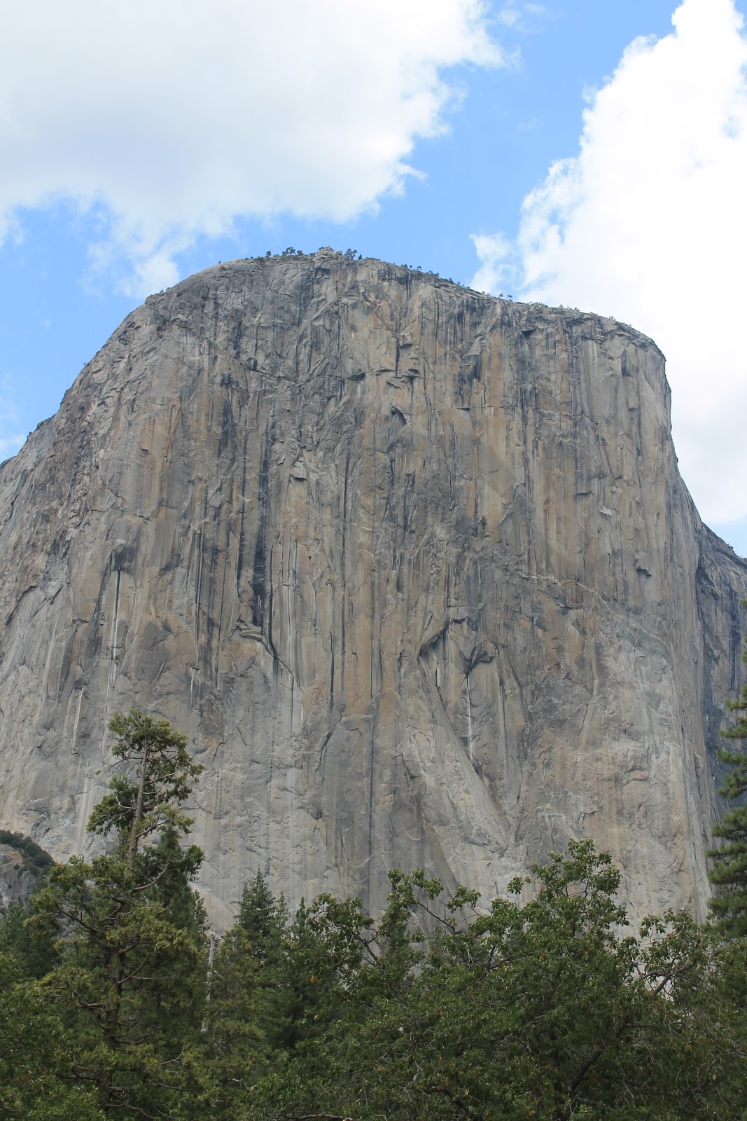
I salute you El Capitan!

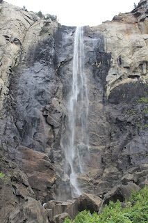
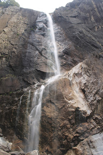
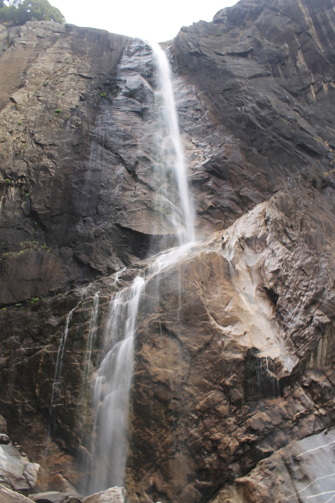
Brideveil Falls.
As we started back down, it started to sprinkle. We managed to get to the car without the heavens fully opening up. By now, Nathan and I were getting hungry, so we parked the car and walked up to where the visitor center and some other shops were. As we started to walk there, the sprinkling became full on rain. The only good thing was that the path had trees lining it so we managed to stay dry by walking beneath them. We were mostly wet by the time we reached a place to eat. As we finished our meal the rains died and we could venture out without fear of getting soaked. In the visitor center I saw a postcard about a fallen tunnel Sequoia tree. I told Nathan about it, and we decided to head up to where it was at as after we saw Yosemite Falls. We hiked a short trail to the base of lower falls. The trail stopped some ways before it though, so we adventured across some rocks to get closer to its base. At one point, I was stepping onto another rock, but it was to slick so that leg dipped into the water up to my shin. Water got into my boot a little bit, but all was still good. I managed to continue on without dipping my other leg into water! We go some pictures there and then head to another trail close by to get a view of Upper Yosemite Falls. There is a trail that leads all the way to the top of it, but with not all that much water coming over the edge in the fall, it wasn't worth it. Maybe if we go back in the spring, we will hike to the top.
Lower Yosemite Falls.

Upper Yosemite Falls.
We got back into the car and drove out of the fallen towards Mariposa Grove where the Sequoia tree was. The drive up the winding road seemed to take eternity. Eventually, we got to the grove. Grabbing our packs we set out for the two-mile hike to the fallen tunnel tree. Along the way we saw some impressive Sequoia trees.

Giant Grizzly tree.

Looking up at the tree.

Me standing in California Tunnel tree.
After seeing those, we kept going toward the fallen tree. It seemed to take forever. In fact, we hadn't seen a sign for it in a little while and we quite possibly thought we were not on the right trail. Finally, as the sun was setting we came across a sign that pointed us in the direction of the tree, but it was still a half-mile to it. Just as we started to head that direction, the wind picked up. Most of the forest that we were in was filled with dead trees from previous fires and they started to drop their branches or giant pine cones. We decided to turn back. We had seen one tunnel tree, we didn't have to see this one. Knowing that darkness was approaching, we quickened our pace down. Soon after we turned around we heard this loud cracking noise. Was that thunder? The cracking sound lasted for a couple of seconds before we heard a TREMENDOUS BOOM! Somewhere in the forest below a tree had decided to fall over!! We kept going down. Soon we came back across the California tunnel tree and we knew that we were getting close to the parking lot. By now, the sun had already sunk below the horizon and all that was left was the lingering light of dusk. With about a half of a mile left to go we came across a group of college students walking down as well. They seemed nervous to be walking in the woods in the dark. One of the girls commented that we had flashlights, so they asked us if they could walk with us down. Slowing our pace drastically so that they could keep up we escorted them down the trail. At one point, I, who was walking in front by a few yards, stopped as a gust of wind came through. I watched a hundred yards away as a pine tree leaned precariously over. It managed to right itself, but some of the other trees near us lost a few small twigs. That put the students on edge. I don't think I helped any, because as we got close to the parking lot and there was almost no light left I spotted something over to my right. I turned around and asked the girl walking behind me, "Would I scare you if I told you there was a Bobcat over there?" I pointed in the direction I had seen it. She immediately said yes and quickly scurried behind me so that I was between it and her. She then asked me where, and I pointed to it. Apparently, she didn't see it and asked again. I pointed again. "Its that machine there." It wasn't an animal, it was just a skid loader! :D Having had my mischievous fun, we continued on the short trek and made it to the parking lot. They thanked us as they headed toward their car and us to ours. Now, we had the long drive of getting back to our campsite ahead. We finally made it there safely close to 10 o'clock. We set about getting ready for bed, which, in this case, meant we had to bear-proof our camp (we got used to that since we did it in almost every campsite) and we also had to bear-proof our car. That was a new one for us! The black bears in Yosemite we very good at breaking into people's cars to get food. So we took anything that looked or smelled like food and put it in the bear box provided at the campsite. That done, we crawled into our tent, ready for the first night in Yosemite.
End day 22.
Friday, September 9, 2011
Hear no evil, speak no evil, see no evil.
Day 21:
My favorite part of hotels is the continental breakfast in the morning, especially if they have cereal. Unfortunately, this hotel doesn't have cereal, but that is OK. They have yummy danishes instead! We left out hotel this morning and walked back through Chinatown to the Transamerica Pyramid, which is the most famous building of the San Francisco skyline.


From there we walked to Coit tower. We didn't go to the top, but from there are we got a better look at Lombart street. Actually, we ended up walking closer to the crookedest street where we got some very cool pictures.

Deciding that we wanted to walk all the way across the bridge, we made the long walk past the wharfs and along the bay coast to the Golden Gate Bridge. We took our time and crossed the bridge. All the while, I was entranced by it.


I know you aren't supposed to look down when you are up high, but I did. To be honest, it wasn't that bad. However, I do have some good advice when on the bridge, don't look up! I mean it! If you aren't holding onto something or leaning on something and look up you will get very dizzy. We made it all the was across and then walked back across it to get to the side we needed to be on. From there we made the long walk to Golden Gate Park. We were looking for a Japanese Tea Garden that was there. After walking ten blocks in the WRONG direction, going to a different part of the park, and finding a Chinese Pavilion that we thought was it, we finally found it. Looking in through the doors, the place was very impressive. Our next stop on the wonderful walking tour was City Hall. We found that without a problem! :D

We were now relatively close to our hotel and since Nathan needed to charge his camera battery, we headed there. A little over and hour later we set back out on the city. We were both very excited to see it at night. The bad news was that it was foggy, so we couldn't make out the bridge or the skyline. Nathan did get an alright picture of Alcatraz with sunset colors in the background.

Saddened, we were going to call it a night. However, there was one thing still to do on our list--take one of the famous cable cars that run through the city.


I was really looking forward to this. Not only for the experience, but also because I didn't feel like walking back up to our hotel! The ride was awesome. It sure is a fun way to travel through the city. When we got near our hotel, we got off and returned to our room.
End day 21.
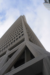
My favorite part of hotels is the continental breakfast in the morning, especially if they have cereal. Unfortunately, this hotel doesn't have cereal, but that is OK. They have yummy danishes instead! We left out hotel this morning and walked back through Chinatown to the Transamerica Pyramid, which is the most famous building of the San Francisco skyline.

A bench in Chinatown area. Hear no evil, speak no evil, and see no evil!

Entrance to Chinatown.

Transamerica Pyramid.

Standing at its base, looking up.
From there we walked to Coit tower. We didn't go to the top, but from there are we got a better look at Lombart street. Actually, we ended up walking closer to the crookedest street where we got some very cool pictures.

Cars navigating the super cool street!
Deciding that we wanted to walk all the way across the bridge, we made the long walk past the wharfs and along the bay coast to the Golden Gate Bridge. We took our time and crossed the bridge. All the while, I was entranced by it.

The massive cables as they reach towards the sky.

Proof that I really was there!

Holding up the bridge!

Taken from the other side.
I know you aren't supposed to look down when you are up high, but I did. To be honest, it wasn't that bad. However, I do have some good advice when on the bridge, don't look up! I mean it! If you aren't holding onto something or leaning on something and look up you will get very dizzy. We made it all the was across and then walked back across it to get to the side we needed to be on. From there we made the long walk to Golden Gate Park. We were looking for a Japanese Tea Garden that was there. After walking ten blocks in the WRONG direction, going to a different part of the park, and finding a Chinese Pavilion that we thought was it, we finally found it. Looking in through the doors, the place was very impressive. Our next stop on the wonderful walking tour was City Hall. We found that without a problem! :D

City hall!
We were now relatively close to our hotel and since Nathan needed to charge his camera battery, we headed there. A little over and hour later we set back out on the city. We were both very excited to see it at night. The bad news was that it was foggy, so we couldn't make out the bridge or the skyline. Nathan did get an alright picture of Alcatraz with sunset colors in the background.

The rock.
Saddened, we were going to call it a night. However, there was one thing still to do on our list--take one of the famous cable cars that run through the city.

We just got off of it and Nathan snapped this pick.

(earlier in the day) A ghost of a cable car!
I was really looking forward to this. Not only for the experience, but also because I didn't feel like walking back up to our hotel! The ride was awesome. It sure is a fun way to travel through the city. When we got near our hotel, we got off and returned to our room.
End day 21.
Subscribe to:
Posts (Atom)